Engehalbinsel (Enge Peninsula)
The Engehalbinsel, in a loop of the Aare north of Bern, was the site of a large Celtic settlement and a small Roman town; remains can still be seen.

- Address
- Engehalbinsel, 3004 Bern
- Built
- Celtic settlement 3rd–1st century BC; Roman town until about AD 165–211 (HLS) or the 3rd century (canton)
- Style
- Celtic oppidum, Roman vicus
- Today
- Woodland and residential area with an archaeological trail, cultural property of national importance
- Protection
- cultural property of national significance (KGS A)
About the building
North of the old town the Aare makes a wide loop and flows almost all the way round the Engehalbinsel. Residential areas such as Tiefenau and Felsenau lie along its southern edge; most of it is forest, the Rychebachwald in the north and the Thormebodewald in the east. Beneath this ground lie the traces of the oldest town on Bernese soil. As an archaeological site the peninsula is listed as cultural property of national importance and is in the care of the Archaeological Service of the Canton of Bern.
According to the Historical Dictionary of Switzerland, the peninsula was settled from the middle La Tène period, mainly in the 3rd and 2nd centuries BC. Probably in the second half of the 2nd century BC the large settlement was protected by ramparts, including a barrier at the narrowest point near today's Felsenau station. The canton speaks of an oppidum of the Helvetii covering up to 140 hectares; it may have been one of the twelve towns mentioned by Caesar. As early as 1849 a mass find came to light near the Tiefenau estate, mostly swords, along with spearheads, shield bosses and parts of wagons. An inscribed zinc plate found in the Thormebodewald in 1984 may give the name of the place: Brenodor.
Shortly before the beginning of our era a small Roman town, Brenodurum, grew up on the same site. Houses with workshops, among them potteries, a bronze foundry and a smithy, lined both sides of a straight road that ran to the tip of the peninsula. In the south lay a cemetery with more than 160 graves, a small amphitheatre and a precinct with three temples, and in the north a bath. Sources differ on when the town was abandoned: the Dictionary concludes from the coin finds that it was between AD 165 and 211, while the canton simply names the 3rd century. Later a pilgrimage chapel of Saint Giles stood over the eastern temple; it was consecrated in 1344 and demolished in 1532.
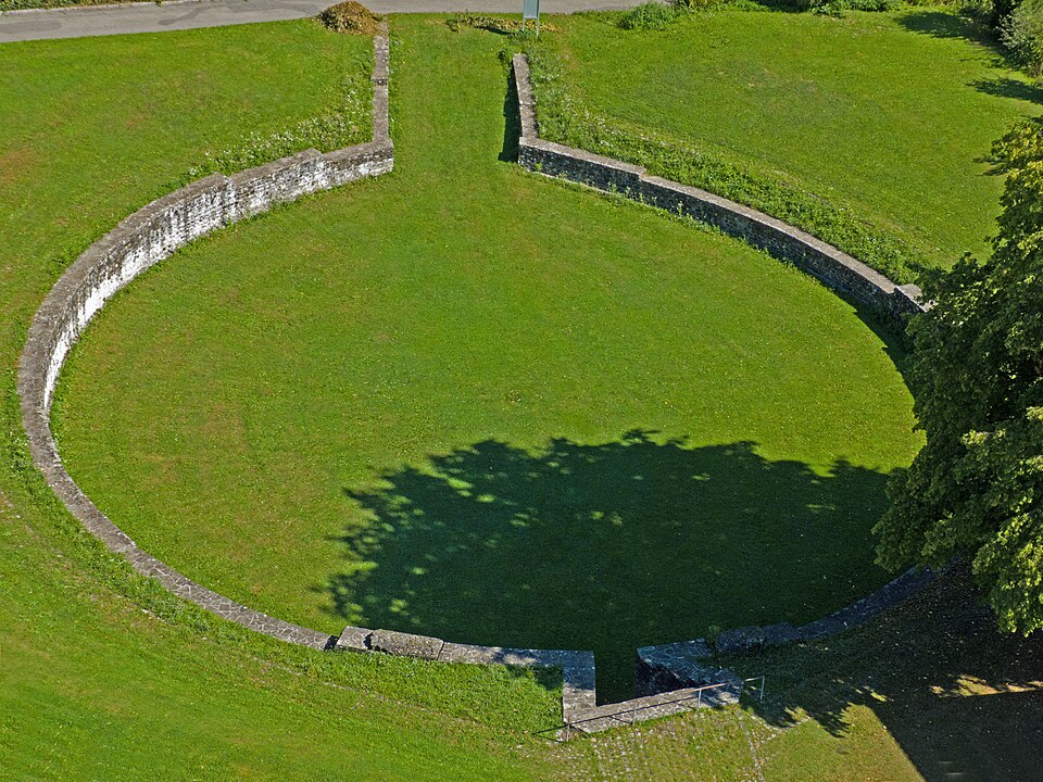
Today the walls of the small amphitheatre are the most visible remains, enclosing an area of about 27.5 by 25.3 metres. They were discovered in 1880 and at first taken for a water reservoir. Next to them stood a powder tower of 1738; only when it had to make way for the Matthäuskirche in 1955 did it become clear what the Roman masonry had been used for. Remains of the Roman bath have also survived, including its underfloor heating. An archaeological trail links the sites. If you want to walk on, small ferries cross the Aare to Bremgarten or to Reichenbach Castle.
Researched and summarised by Bärn Kit. Sources: Archäologischer Dienst des Kantons Bern: Bern, Engehalbinsel · Historisches Lexikon der Schweiz: Bern (Gemeinde), Ur- und Frühgeschichte, Römische Zeit · Historisches Lexikon der Schweiz: Oppidum · Wikipedia (de): Engehalbinsel · Wikidata: Q1341754
Buildings nearby
Reformed Church of St Matthew200 mHeiligkreuz Church (Holy Cross)210 mFelsenau Viaduct870 mAltersheim Jolimont960 mFormer Bern Slaughterhouse1030 mYouth with DoveArtwork · 10 mLarge Piano RhythmiqueArtwork · 20 mCircus horses, always a dream of mineArtwork · 60 mClassification and address: Bauinventar © Amt für Kultur des Kantons Bern · Wikidata. Found a mistake? Write to hallo@uebrig.ch.